

| Home | Group Members | Research Areas | Research Facilities | Research Collaborations | Classes | Publications | News & Awards | Directions to NCEL |
Contact Info:
Mark J. Rood, Ph.D.
Ivan Racheff Professor of Environmental Engineering
Department of Civil and Environmental Engineering
University of Illinois
3230E Newmark Lab, MC-250
205 N. Mathews Ave.
Urbana, IL 61801 USA
Tel. (217) 333-6963
Fax. (217) 333-9464
mrood@illinois.edu
Remote Sensing of Dust Plume from Movement of Tracked Vehicles
Clip - Measurement of fugitive dust emission from vehicle
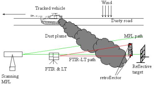
| A MPL system and two OP-FTIR and OP-UV-VIS hybrid duel spectroscopic systems will be deployed concurrently in the downwind side arranged in a vertical plane. The vertical measuring plane will be parallel to the path of the vehicles. The purpose of obtaining this vertical array of data is to determine and account for the spatial orientation of the plume while calculating the preliminary mass emission fluxes. The MPL will scan vertically to determine the vertical and horizontal dimensions of the dust plume generated by tracked vehicles. The MPL system will be combined with a series of in-situ point and OP monitors to measure the emission fluxes of the tracked vehicles. The lidar system provides backscattering data across a vertical plane downwind from the emission sources. Extinction data from hard targets will be collected in front of and behind of the plumes. This information extends the range of the measurement and completes the extinction profile across the plume. As the system measures the extinction of light in the target plumes, extinction by dust is mapped. As the MPL data generates the extinction profile across the plume, vertical gradients in the particles' size and mass distributions will be determined by the OP duel-spectroscopic systems. These measurements along with a presumed specific gravity for desert dust provide a plane integrated mass concentrations of dust in the downwind vertical plane. This, along with wind field measurements, will allow determination of mass emission fluxes for the selected PM sources. The in-situ point and the other OP monitors will acquire data concurrently. The correlated information from both measurement methods will be used to generate the spatial distribution of mass concentrations in the vertical plane. Integrating the mass concentration values provides the plane integrated mass concentration, which is the first part of the emission flux measurement component. The second part of the measurement component is the wind field in the vicinity to the vertical plane. The combination of dust mass concentrations, cross-sectional area of the plume, and wind speed will provide the mass emission of the dust from the military source. |
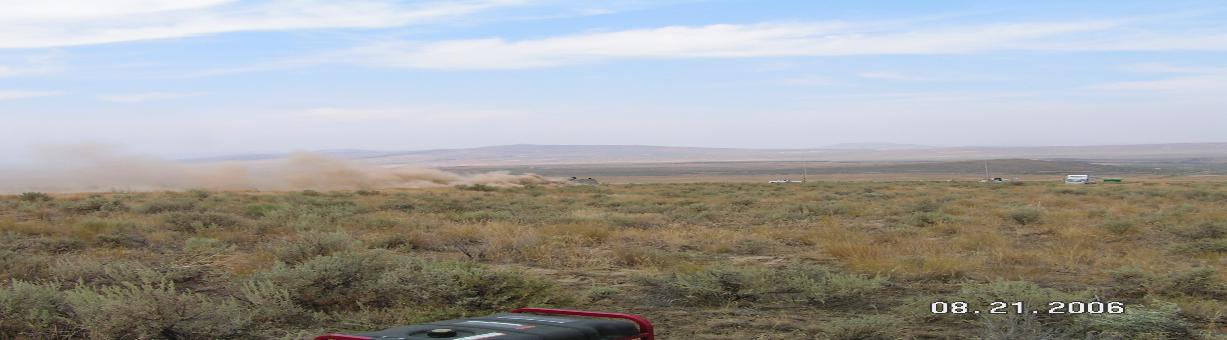
Sample plume image: A dust plume generated by a tracked vehicle traveling on an unimproved road
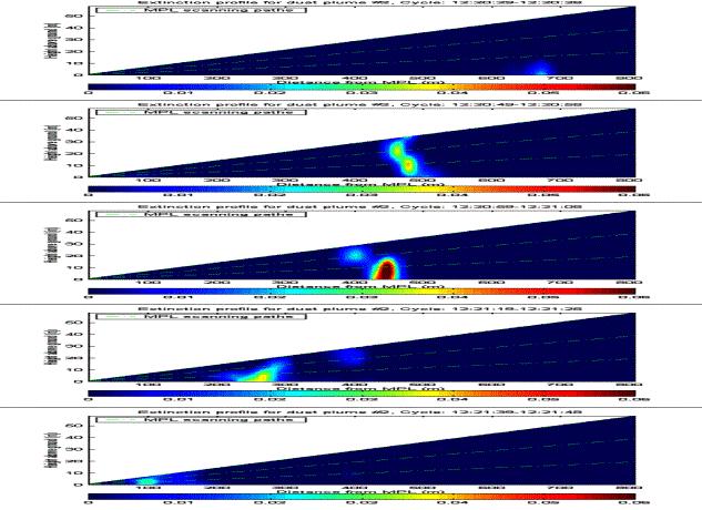
Evolution of plume extinction profile during a vehicle travel
(Bradley Tank, moving at 20 mph towards the MPL)